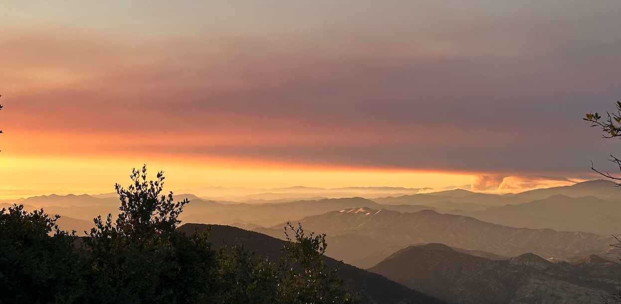
Night #1 of the Gifford Fire – as seen during a LPFA Volunteer Trail Project on the Mission Pine Trail, photo David F.
Hello Friends,
Unless you’ve been living under a rock or out on vacation, then no doubt you’ve been following the progression of the Gifford Fire. The Gifford Fire started on the afternoon of August 1 near the Gifford Trail along Hwy 166. It quickly spread into the Los Padres in both a southerly direction into Santa Barbara County as well as north into San Luis Obispo County. Now 10+ days later, Gifford is the largest California wildfire this year having chewed up nearly 125,000 acres and currently stands at 33% containment.
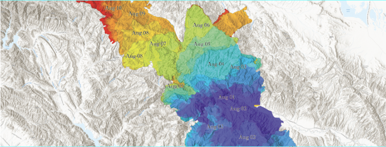
During the initial days of the fire, Gifford made a strong push into Santa Barbara County, burning east along the Sierra Madre, over Miranda Pine, down into Pine Canyon and ultimately into the San Rafael Wilderness. Fortunately, favorable conditions and previous fire scars (La Brea 2009, Spanish 1999) helped check the fire. At the moment, it seems that the southern flank of Gifford within Santa Barbara County has been stopped. Knock knock.
Meanwhile, most of Gifford’s progression has been directed north into San Luis Obispo County, where it continues to burn. There have been a few previous wildfires within the SLO Backcountry (Madre 2025, Logan 1997, Hwy 58 1996, Las Pilitas 1985) which have helped slow down the fire but unfortunately Gifford is burning many areas of the Los Padres which have no recorded burn history. NOTE: We’re sadly running low on portions of the forest which have not burned.
While fire crews have accomplished a solid containment perimeter around much of the fire, most of the current fire activity is on a north-west trajectory through the Garcia Wilderness. The weather forecast is looking good for fighting the fire and crews have been working day & night to finish containment lines around the fire, especially off Hi Mountain Road. There are active firing operations designed to box the fire into the Garcia and hopefully prevent any further progress into the Santa Lucia Wilderness. We are very fortunate to have nearly 5,000 personnel helping to assist with the fire fight. THANK YOU EVERYONE INVOLVED! Lets wish them all safety, good luck and favorable weather!
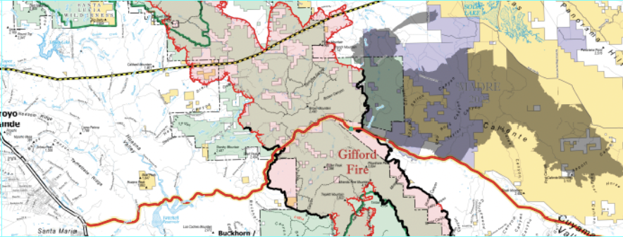
GIFFORD CLOSURE
In response to the Gifford Fire, the LPNF has issued an emergency closure order which covers the entirety of the Santa Lucia Ranger District and a section of the Mt Pinos west of Santa Barbara Cyn along the Sierra Madres. This includes a closure of Figueroa Mountain, NIRA Trailhead, the Manzana/Sisquoc and obviously all of the SLO Backcountry:
IMPACTED TRAILS / CAMPS
We’ve received quite a few emails asking about the status of camps and trails burned by Gifford. Here’s a quick and incomplete list.
Trails: Avenales, Stony Creek, Caldwell/Trout Creek, Sellers Potrero, Kerry Cyn, Indian, Willow Spring, Adobe, Rock Front OHV….
Campgrounds: Miranda Pine, Brookshire and others……
For more information and maps covering the Gifford Fire, check both CalFire as well as InciWeb. Note that evacuation orders and warnings are changing daily, if not hourly.

- The first of three extended weekend closures of Highway 33 by CalTrans for bridge repairs begin this Friday, August 15th. The closure dates are: Aug 15-18, Aug 22-25, Sept 19-22. During these dates, there will be no public access along Hwy 33 between Ojai and Wheeler Gorge. The Wheeler Gorge Visitor Center will be closed on these weekends, but campgrounds and trails further up the 33 are open to access from the north.
- The Wheeler Gorge Campground will be closed until January 3, 2026 for reconstruction of creek crossings within the campground. This project will restore 13 miles of connected stream habitat for Southern California Steelhead. While the campground is closed, consider camping at alternative nearby campgrounds including Rose Valley, Middle Lion, Pine Mountain or Reyes Peak!
- A hiker has been missing along the southern Big Sur coast since August 5th. He is believed to have been hiking in the Ragged Point area and was last seen wearing a white shirt, bright blue shorts and a multicolored or tie-dyed pastel backpack. Help spread the word and call the SLO County sheriff with any information.
- The Canyon Fire ignited southeast of Lake Piru on the afternoon of August 7th. The fire burned over 5,000 acres just outside of the Los Padres but is now at 96% containment with all evacuation orders lifted.
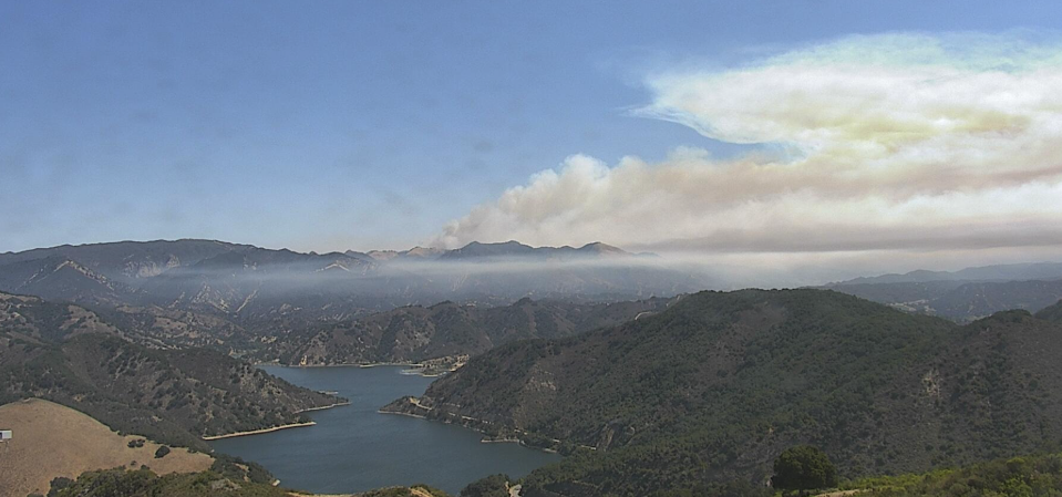
View of the Gifford Fire over Lopez Lake burning the Garcia Wilderness taken August 12 at 11:30am. Click photo for live shot.