Fire Openings Across the Los Padres

FIRE OPENINGS & RESTRICTIONS

Hello Los Padres & Happy Holidays – It’s been a monumental day in the LP with quite a few shakeups that most of you will be happy to hear about.  Lets get to it!

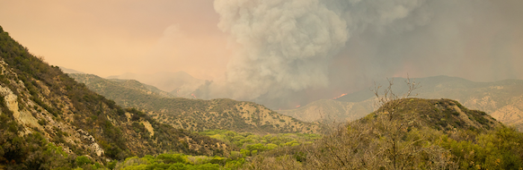
Earlier today the Forest Service lifted the fire closures on the REY FIRE, SHERPA FIRE and PINE FIRE.  All regular recreational activities are now permitted within these fire perimeters.  This includes hiking, camping, riding and biking & OHV where applicable and legal.

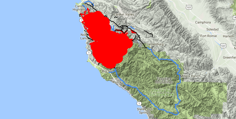
In addition, the Forest Service reduced the closure of the Soberanes Fire and opened up most of the southern portion of the Monterey Ranger District.  The heart of the Soberanes burn area remains closed and will most likely stay closed through next spring.  For more information on all the fire openings and adjusted closures, check this link here and see the attached map showing the current Soberanes Fire closure.

Want more?  On November 29 the Forest Service downgraded the fire restrictions from Level IV to Level II.  Level II allows portable stoves across the forest, campfires at Designated Campfire Use Sites and target shooting at designated locations.  Check the links for more details.

The changing of these closures is somewhat unexpected but it is good news, at least for most of us.  Please remember that the hillsides and trails within the burn areas are still settling.  Be careful, tread lightly, avoid during rain, listen to your internal ‘common sense meter’ and have a backup plan in case the trail you’d like to explore is impassable.  Otherwise, have at it!

— • — • — • —
2017 LOS PADRES CALENDAR
The 2017 LPFA wall calendars are done, they’ve been sent to the printers and we should have them in-hand and ready to distribute by December 15!  Thank you to everyone who contributed photos for the calendar.  We had over 125 photos submitted by almost 30 different photographers.  It was hard work paring down the photos and selecting the final pictures that would appear in the calendar but we think the calendar turned out really nice.  We’ve got a good collection of photos from across the forest and covering themes from wildlife to wildfire, flowers to trailwork and sea level to almost 9,000ft.  If you like the Los Padres, we think you’ll love the calendar.  If you’d like to purchase a calendar, pre-sale is still available at the following link.  Thanks so much again to everyone who helped out and have a great 2017!
— • — • — • —


Cottonwood Fallburst, photo Heidi Anderson
UPCOMING EVENTS

We spent some time this past week scheduling the 2017 LPFA volunteer trail projects.  2017 will hopefully be highlighted by a Working Vacation based at Manzana Schoolhouse in April and a second Working Vacation at Madulce in May – we’ll keep you updated.  In the meantime, our next backcountry trail project is December 16-18 working down the Judell Trail in the San Rafael Wilderness.  We’ll be car-camping at the trailhead and working down from the top removing fallen trees and brush from the trail corridor.  We’re also working on some sort of holiday theme for the weekend, so you might want to get your ugly Xmas sweaters out of the closet and primed for action.  If you’re interested in helping that weekend, email us at INFO@LPForest.org or email project leader Mike Smith at TrailSmith@LPForest.org.

And lastly, if you enjoy these email updates and appreciate the information we provide, become a LPFA member and support the cause.  We’ll send you a sticker and perhaps a few other goodies but more than anything else your membership helps drive the ship and keep us doing what we do best – working the trails, educating the public and helping the forest along the way.  You can click here for the membership page and thank you for reading this far along – perhaps we should become members of you……

LOS PADRES Concessionaire Changes & More……

Chuchupate Camp, Showing Signs of Changechuchupatecamp
LOS PADRES CONCESSIONAIRE CHANGES

Big changes within the Los Padres are upon us, perhaps you’ve heard, if not, then brace yourself… For the past three decades the Los Padres National Forest has relied on as many as six different privately run concessionaires to help manage some of the campgrounds, day use areas and trailheads around the forest. You’ve seen these concessionaires at the campgrounds along Paradise Road, at Wheeler Gorge Campground, McGill, Bottcher’s Gap, Cerro Alto, Kirk Creek, etc, the list goes on and on. In an effort to consolidate these concessionaires, the Forest Service has selected Parks Management Company to become the sole concessionaire across the Los Padres. This went into effect November 1.

Yet, in addition to taking over the existing concessionaire operations and as part of their new agreement with the Los Padres, Parks Management will be adding quite a few new recreation sites to their list of concessionaire sites. This is where it gets a little painful, as some of the sites you’ve been using for free or as part of the Adventure Pass program are now going to be managed by Parks Management and will cost quite a bit more to use than in the past. Campgrounds like NIRA, Pine Mtn and Chuchupate, that used to accept a $5 Adventure Pass, are now going to charge $20/night. And certain trailheads like Upper Oso and NIRA, which also used to either require a $5 Adventure Pass or were free, are now going to cost $10/day to park. Ouch.

We’ve met with the FS and Parks Management multiple times expressing our concerns and hearing their sides of the concessionaire triangle. We all know how rundown some of the campgrounds are and we hear about how the Forest Service budget has been cut by 50% over the past decade. Like it or not, the FS doesn’t have the capacity to adequately manage all the recreation sites across the forest. As it was explained to us: with the current budget, it’s either accept a broader concessionaire program or run the risk of losing those recreation sites altogether. It’s a depressing situation and we’re not sure anyone knows a perfect solution.

While these price increases are going to be a tough blow for those of us who regularly use the forest, we’re already starting to see improvements at many of the campgrounds across the forest. These improvements include freshly painted bathrooms, new campfire rings, brush removal around campgrounds, new tables, etc…. For only being two weeks into their new agreement, it appears Park Management is headed in the right direction. Lets hope they keep it up.

One of the downsides of the new concessionaire plan is that it’s caused quite a bit of confusion trying to figure out which campsites require which permit. In order to help, we’ve created a GoogleDoc spreadsheet listing all the recreation sites mentioned in the concessionaire change documentation. We’ve listed all the sites, what the previous regulations were, previous costs and then what the current regulations/costs are:

Click here and you can sort through and check out the sites that most interest you.

As you will see, there is a lot of change. Most of it translates to more cost for the forest-user but hidden in the new program are some good changes as well. Some additional tidbits:

  • Parks Management will sell a $50 annual day use pass that is good across the forest.
  • The Adventure Pass remains in effect at select sites, see GoogleDoc.
  • Parks Management will provide 50% campground discounts with the America the Beautiful annual passes.
  • Many of the Parks Management campgrounds will be available for online reservation but they will keep some first-come-first-serve sites within the campgrounds as well.

As mentioned, this change went into effect November 1 and Parks Management expects it to take a few months in order to get all the iron rangers installed and signage changed across the forest. It’s going to be a tough pill to swallow, especially as we all learn what exactly this means and what the long-term ramifications are of this program. Lets hope that this is a positive in the long run.

— • — • — • —

Autumn Super Moon, photo Humphreysupermoon

CURRENT CONDITIONS

It’s been a minute since we sent out a forest update.  Amazingly, quite a few of you missed the update and checked in asking if everyone was going okay.  The answer is YES, things are great, just a little too busy the past month to put one of these emails together.  Since it has been a while, we wanted to send out an update on the current conditions, closures and restrictions across the LP.

LEVEL IV FIRE RESTRICTIONS
The forest remains in Level IV fire restrictions, which means no campfires, no target shooting and no stoves outside of designated campfire use sites.  You can see the restriction order here.  While the forest has received some substantial rain this season, the fire restrictions are generally not lifted until the entire forest receives at least two inches of rain.  Last year the restrictions were not lifted until early January.  There are rumors that the restrictions may be downgraded to allow portable camp stoves in the backcountry, if anything changes we’ll let everyone know.

SOBERANES FIRE CLOSURE
The Soberanes Fire burned over 130,000 acres across Monterey County from July 22 until October 22.  Soberanes ended costing more to fight than any fire in US history.  In response to the fire, the Forest Service closed the Monterey Ranger District on September 2 and that closure remains in effect.  While the Soberanes Fire is 100% contained, it continues to burn and smolder within the fire perimeter.  No news on when the closure will be modified but we expect the fire perimeter to remain closed at least until the end of next spring.  We’ll keep you posted……  In the meantime some of the campgrounds along the Big Sur Coast have reopened.  The Forest Campgrounds off Hwy 1 are open as well as Andrew Molera State Park.  If you’re planning a trip through Big Sur, be sure to check on campground availability before you hit the road.

SANTA LUCIA RANGER DISTRICT
Many of the roads and recreation sites around Figueroa Mountain remain closed due to hazard trees.  Fig was hit perhaps harder than anywhere else in the Los Padres by the drought and subsequent beetle infestation.  Take a look at Figuera Mountain next time you’re in the Santa Ynez Valley and you can clearly see the swath of brown dead trees.  The closure includes Catway Road, Figueroa Lookout, Pino Alto, Cumbre and East Pinery Road.  You can read more here.

SANTA BARBARA RANGER DISTRICT
The Rey Fire perimeter remains closed within the SBRD.  This includes all trails up the Buckhorn Rd above Upper Oso Campground as well as the burn areas accessed from the Indian-Mono Trailhead near Mono Campground.  While there might be some minor adjustments in the closure order, we do expect the Buckhorn Road and trails to remain closed to hikers, OHV and mountain bikers at least through the winter.  Stay tuned.

Also in the SBRD we have remaining closures as a result of the June Sherpa Fire.  The closure mostly affects West Camino Cielo.

OJAI & MT PINOS RANGER DISTRICTS
Recurring theme, the Pine Fire closure from earlier this summer remains in effect.  The closure specifically affects the Reyes Peak Trail and the Piedra Blanca Trail between Upper Reyes Creek and Pine Mtn Lodge.  The Forest Service has been busy installing warning signs where the trails enter the burn area.  While warning signs might indicate that people will soon be allowed into the burn area, no dates have been announced when the closure will be lifted.  Hang tight……

The Ojai Ranger District announced their seasonal road closure schedule.  This year the gates to Dough Flat (at Tar Creek), Reyes Peak (Pine Mtn), Cherry Creek and Nordhoff Ridge will close on December 16.  The Pines Campground above Ojai remains closed due to hazard trees.

Mt Pinos District is doing something a little different this year and will be locking gates along their seasonal roads based on rain events rather than specific dates.  The gates will close after the first large rain.  This is a great approach and I’m sure most of us reading this are happy to hear about the change in policy.  For more details or to check on gates, give MPRD a call at 661.245.0521.

Whew, that’s a lot of information.  Let us know if you have any questions or if we messed anything up.  Thanks everyone for the updates……

— • — • — • —

McKinley Mtn View, October 2016 Mission Pine Working Vacationmckinleypano

UPCOMING EVENTS
A few upcoming dates, events, projects, presentations or things you might want to know.
If you have any forest-related events to add to this list, let us know and we’re more than happy to pimp your event!

November 20: SBMTV San Ysidro Trail Work & Ride
November 27: LPFA Manzana Trail Tree Clearing

December 3-4: LPFA VWR Headquarters Cabin Cleanup
December 18-20: LPFA Judell Trail Maintenance Project, details upcoming

January 21-22: UTMC Crosscut Certification, Chuchupate Ranger Station


Fire, Fuego, Feuer, Feu, Fuoco: Update & Restrictions

Rey Fire, Friday August 19 the Day it Got Away, photo Mike Kent
ReySunset
Hello Everyone,

Obviously the conversation these past few days, weeks and now months has been centered around the fires raging across the Los Padres.  First we had Coleman, then Sherpa, Pine, Soberanes, Rey and even the Chimney Fire is now threatening LP lands.  And this list doesn’t include the hundreds of smaller fires that we never even hear about.  I was fortunate today to attend the Rey Fire morning briefing at fire camp.  I’d never really been in a fire camp before.  The amount of organization involved in fighting a large fire is simply incredible.  There were lines of fire engines waiting to fill up at water tenders, food stations prepared to feed thousands of meals each day, crews from all over the place, what seemed like miles of tents, countless trucks color coordinated into neat sections (FS green over there, Cal Fire red that way, etc…) and all the sanitation needs from trash to porta-potties to hand washing stations.  It was part music festival, part sporting event; without the festivity and with an air of stern professionalism.  A portable city that moves around the Western US as needed and where needed with the sole purpose of stopping fires.  This was clearly not their first rodeo.


Lead pilot Doug is the man!  photo Humphrey
LeadPlaneDoug
It’s easy for those of us watching the fires from the sidelines to ‘Monday morning quarterback’ and complain about why they didn’t save our favorite campsite or how they couldn’t hold that ridge.  Trust me, I’m guilty.  But we have to remember that they are the professionals.  They are out there cutting lines in 100˚ heat.  They are flying through smoke a mere hundred feet above flames.  They are the ones balancing resources and making decisions where life is literally on the line.  A bad decision here or there could lead to injuries or potentially a city burned to the ground.  That’s heavy.  Trails can be reworked, plants (mostly) will grow back and we’ve seen animals will survive.  It sucks that we’re all dealing with fires but after today it was crystal clear that once you have a wildfire, you have to trust the process and believe in the fire crews.  This is not their first rodeo (this month).

Rey over Mono Jungle, photo Ray Ford
MonoRey

Leaving the fire camp this morning I wanted to cheer on the crews as they left to cut lines or coordinate air attacks.  I literally wanted to stand on the side of the road and cheer them on as if they were an NFL team running out of the tunnel and onto the field.  And I wanted to wave a flag that said “WHATEVER YOU DO, PLEASE SAVE ALAMAR TRAIL”.  Momentary kidding aside, thank you to everyone involved in the fire.  EVERYONE.  They say it takes a village, but in this case I can tell you it takes more than that.  It takes a city, and sometimes more than one.

— • — • — • —

If you want to follow the progress of the Chimney, Soberanes or Rey Fire, the best place is on Twitter and search for that fire.  We’ve been updating information on the LPFA Facebook page and Twitter page or you can check Inciweb as well.  There is no shortage of information out there.

— • — • — • —
Along these lines, the Los Padres Forest went into Level IV fire restrictions earlier today.  See attached PDF for more information.  Basically Level IV prohibits any campfires within the Los Padres Forest.  PERIOD.  The difference between this years restrictions and those of the past few years is that this year the use of portable stoves outside of the designated campfire use sites is also prohibited.  This means anyone venturing outside of the campfire use sites or into designated wilderness areas will be eating cold food and drinking cold drinks.  Again, see attached PDF for more details and please follow these restrictions.

— • — • — • —
UPCOMING EVENTS
A few upcoming dates, events, projects, presentations or things you might want to know.
If you have any forest-related events to add to this list, let us know and we’re more than happy to pimp your event!


September 10: NPLD Jesusita Trail, Santa Barbara Frontcountry
September 11: Island View Trail Race, Franklin Trail, Carpinteria
September 14: LPFA Backpacking Fundamentals Class
September 20: LPFA Trail Talk Series, History of Los Padres Lookouts by Craig Carey
September 24: National Public Lands Day Trail Project, Lion Canyon Trail, Ojai


October 1: LPFA Used Gear Sale
October 16: D-13 Hunting Season Starts
October 22-30: LPFA Working Vacation, Poplar Trail (ON HOLD)
October 29: LPFA First Aid & CPR Training

What Dog Days?: Madulce Trail Project, Soberanes and much much more…….

Madulce Peak & Trail
MadulceTrail
Hi Everyone – Happy Thursday,

Even though we’re in the dog days of summer, there is no shortage of activity across the Los Padres.  We’ve got a jam-packed email focusing on many of the events and incidents within the LP; lets get to it!  If there is anything missing or you’d like included in future emails, please let us know……..

MADULCE TRAIL PROJECT
The LPFA is leading a trail project along the Madulce Trail in the Dick Smith Wilderness on the weekend of August 12-14.  We’ll be driving in to Alamar Saddle and setting up basecamp at Alamar Camp.  It will be a car-camping trip with a short drive up to the Madulce Trail to work both Friday afternoon and Saturday.  The work will be mainly logging and tread work along the top 2 miles of the Madulce Trail.  The work site is around 6,000ft, on the north side of Madulce Peak and mostly shaded by pine trees.  It should be a good location for working even in hotter temperatures.  Mike Smith is the project lead and we’re hoping for 15-20 volunteers.  Food and tools will be provided by the LPFA.  It’s going to be a great time and a nice opportunity to get into the backcountry to help any NDD issues you might be suffering from.  If you are interested in joining please email INFO@LPForest.org or check Facebook or Meetup for more details.  Hope to see you there………

Soberanes Fire – August 4, MappingSupport.com

Soberanes160804
SOBERANES FIRE
Quick update on Soberanes in the Monterey Ranger District.  The fire continues to grow and is primarily burning south into the Los Padres and Ventana Wilderness.  The fire has currently burned 51,000 acres and is 27% contained.  The FS just issued a new closure order, see attached PDF map for details.  The cause of the fire was revealed yesterday as being an illegal campfire in Garrapata State Park.  Twitter remains the best source for up-to-the-second information and Inciweb is the place for official information related to the fire.  There is some good news and bad news that also surfaced this week.  Good news is that there is a large-scale weather change in the forecast that will bring higher humidity and cooler temperatures to the area starting this weekend.  That will help.  The bad news is that fire personnel have been mentioning that Soberanes has the potential to burn over 170,000 acres before it’s all said and done.  The steep terrain and inaccessible country that we all love about the Ventana is making constructing fire lines virtually impossible.  Everything to the immediate south of the current fire perimeter is within wilderness, which means that very few man-made structures are at risk.  Mix in the cost and safety concerns associated with fighting fire in the difficult to access portions of the Ventana and it appears that the current strategy might be to construct fire lines around much of the Ventana and let the backcountry burn inside those fire lines.  This is the same approach that was used in the 2007 Zaca Fire.  If you look at the image above, red indicates the current fire perimeter and the blue lines are the projected fire lines.  We’ll keep you posted as the fire progresses and lets all be sure to thank the fire and support crews and wish them the best of luck as they continue to get the upper hand on Soberanes.

FOREST 411
Reyes Peak (aka Pine Mtn) Road has reopened in the Ventura Backcountry.  Along with the road reopening both Pine Mtn and Reyes Peak Campgrounds have also been reopened.  Note: Reyes Peak Trail towards Haddock remains closed as does the Piedra Blanca Trail between Upper Reyes and Pine Mtn Lodge.  These closures were a result of last months Pine Fire.

• The Los Padres National Forest is hiring within the Wildland Firefighter Apprenticeship Program.  Interested candidates can apply at www.USAJobs.gov starting 8/11 – 8/25.  Additional information available here.

SLO based VWR’s Bill and Sandy Obermeyer, Debbie and Ron York & Ashley and Joe Dillard
worked the access road for Rinconada Trailhead making it drivable for equestrian trailers once again.  A+!
RangerBill
UPCOMING EVENTS
A few upcoming dates, events, projects, presentations or things you might want to know.
If you have any forest-related events to add to this list, let us know and we’re more than happy to pimp your event!


August 7: West Fork Cold Spring Trail Maintenance, SBMTV, Santa Barbara Frontcountry
August 11: Santa Ynez Valley Historic Museum, Chumash Trails
August 12-14: LPFA Madulce Trail Sawyer Project
August 13: A-Zone South Hunting Season Starts

September 8: Santa Ynez Valley Historic Museum, Walking El Camino Real
September 11: Island View Trail Race
September 14: LPFA Backpacking Fundamentals Class
September 20: LPFA Trail Talk Series, History of Los Padres Lookouts by Craig Carey
September 24: National Public Lands Day Trail Project, Lion Canyon Trail, Ojai

October 13: Santa Ynez Valley Historic Museum, Rangers of the San Rafael Wilderness
October 16: D-13 Hunting Season Starts
October 22: LPFA Used Gear Sale
October 29: LPFA First Aid & CPR Training

Fires Wrap Up & Condor Trail Talk

Condor Trail View, SLO Backcountry
BryanConant_SLO2SB_1600x400
TRAIL TALK: Condor Trail with Brittany Nielsen

Don’t forget that the 2nd LPFA Trail Talk event is this Thursday at 6:30 in Santa Barbara.  We’ll be welcoming CT Thru-hiker Brittany Nielsen to talk about her journey and time along the Condor Trail.  Space is limited so be sure to sign up ahead of time.  More information can be found here and you can get your tickets here.  We’ll have a raffle featuring items from Patagonia and REI and some other fun and surprises.  Hope to see you Thursday night!

Also, Brittany will be appearing on KCSB radio 91.9 today at 5:00pm.  Check it out on the air or streaming.

Pine Fire Drop, Ventura County Sisar Peak Camera PineFireSisar

FIRES ON THE MOUNTAIN

The skies are currently clear but it’s already been a busy 2016 fire season.  It seems that as soon as one fire is under control, another one is just getting started.  Lets hope that trend stops with the Pine Fire.  Currently all three major LP fires are over 90% contained with mostly mop-up duties remaining.  While some closure orders remain active, the FS has been reopening some previously closed portions of the forest.  See below for more information regarding each incident and remember that the Los Padres remains in Level III fire restrictions.

COLEMAN FIRE – Started June 4 – 2,520 acres – 96% contained – Monterey County
Inciweb Information
Map Image

SHERPA FIRE – Started June 15 – 7,474 acres – 100% contained – Santa Barbara County
Closure Order
Inciweb  Information
Map Image

PINE FIRE – Started June 30 – 2,304 acres – 93% contained – Ventura County
Closure Order (and attached)
Inciweb Information
• Map Image (see attached)
Article about mules supporting fire crews

See, there still is some water out there!  Big Sur Cascade
Remember to check HLP for more recent water information

BigSurCascade
UPCOMING EVENTS

A few upcoming dates, events, projects, presentations or things you might want to know.
If you have any forest-related events to add to this list, let us know and we’re more than happy to pimp your event!


July 21: LPFA Trail Talk Series, Condor Trail
July 24: REI Trail Run Series, Elings Park

August 11: Santa Ynez Valley Historic Museum, Chumash Trails
August 11-13: LPFA Madulce Trail Sawyer Project
August 13: A-Zone South Hunting Season Starts

September 8: Santa Ynez Valley Historic Museum, Walking El Camino Real
September 11: Island View Trail Race
September 14: LPFA Backpacking Fundamentals Class
September 24: National Public Lands Day Trail Project, Lion Canyon Trail, Ojai

October 13: Santa Ynez Valley Historic Museum, Rangers of the San Rafael Wilderness
October 16: D-13 Hunting Season Starts
October 22: LPFA Used Gear Sale
October 29: LPFA First Aid & CPR Training

Condor Trail Talk Series & Pine Fire

CT_Banner

Hi Everyone,

We’ve got some exciting news to share about the LPFA Trail Talk series of events.  Brittany Nielsen will be coming up to Santa Barbara on July 21 to give a talk about her 2015 experience thru-hiking the 421 mile Condor Trail from Lake Piru (Ventura County) to Bottcher’s Gap (Monterey County).  This is our second Trail Talk Series event and will once again be held at the Santa Barbara Veterans Hall off Cabrillo Blvd right across from the beach.  The talk is free for LPFA members or $10 for guests and includes a complimentary social happy half-hour both before and after the talk.  We’ll top it off with a few additional speakers, some trivia games and a raffle.  You can learn more on www.LPForest.org, become a LPFA Member here or get your tickets directly at EventBrite.  If you have any questions about your LPFA membership, please contact INFO@LPForest.org.  Thanks everyone, Brittany has a great story to share and we hope you are interested in attending.  Looking forward to seeing you there……..
PINE FIRE, SESPE WILDERNESS
PineFireMap160630

Another wildfire started Thursday morning along Pine Mountain in the Ventura Backcountry.  The exact location of the fire is still being worked out but the map above is the best information we could find as of now.  The Pine Fire is along the Gene Marshall – Piedra Blanca National Recreation Trail (also part of the Condor Trail) in the vicinity of Haddock Camp and the upper reaches of Beartrap Canyon.  This is a very steep and rugged portion of the forest in the neighborhood of 6,000ft elevation.  The area features large rock outcrops with patches of chaparral around predominantly pine trees.  The Pine Fire is currently at 300 acres and is being hit hard with air tankers and fire crews.  The weather forecast for the weekend is promising as winds should be light and temperatures are going to be on the lower side.  There are road closures as a result of the fire and both Hwy 33 and Lockwood Valley Rd are scheduled to be closed to thru-traffic this weekend.  If you’d like to keep an eye on the fire, your best bet is to use Twitter and follow #PineFire or on Inciweb.  Both the Wolf Fire (2002) and Day Fire (2006) burned near here but we don’t know when the last time this area specifically burned.

Best of luck and thanks to everyone involved in fighting the Pine Fire!