The Lake Fire started in the late afternoon July 5 somewhere in the Zaca Lake drainage. The cause of the fire is still under investigation. The Lake Fire ignition point was very close to where the Zaca Fire had started 17 years and 1 day earlier on July 4, 2007. If you are reading this, then you probably have some interest in this wildfire and where / what it might burn in the days, weeks and perhaps months ahead.
While the weather will largely dictate the direction and duration of the Lake Fire, we can also look at the behavior of past wildfires and study decisions made during those fires to help understand where this current wildfire might be headed. This is known as the fire history. Fire history is a tool that can show us many things such as the strategy of how previous wildfires were fought, where historic firebreaks have held or lost the fire, how many years (or decades) of vegetation fuel might be ahead of the fire and more.
Just to be clear, we’re not professional fire predictors by any means. We aren’t meteorologists. We aren’t fire behavior specialists. We don’t have a seat at the table when fire decisions are being made. But we know the Los Padres and we have seen too many wildfires ravage our beloved forest. If you spend any time in this forest, you know how devastating these fires can be to the vegetation, the waterways, the critters, the trails and our ability to recreate in the forest we love. That being said, let’s take a closer look at the Lake Fire and the fire history in this part of the Los Padres. Perhaps we’ll see some trends to help figure out where and for how long the Lake Fire might be burning.

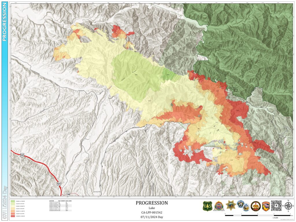
This first map shows the Lake Fire perimeter as of July 10, 2024. The fire started near Zaca Lake and initially headed west from there. Over the past few days, as the western winds returned to normal, the fire has been mostly pushing to the east, northeast and lightly to the north. Most of the firefighting efforts have rightfully been aimed at keeping the fire from heading south and west into ranches, vineyards and communities. The fire crews did a great job over the initial days of the Lake Fire to slow the fire down and protect the communities. Bravo.

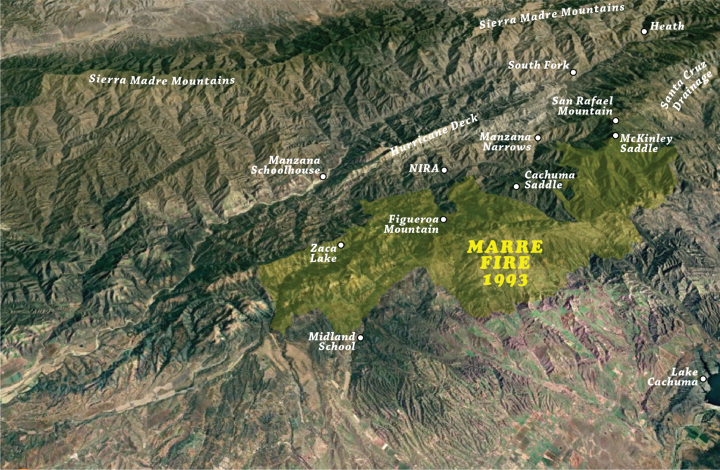
This second map shows the perimeter of the 1993 Marre Fire. Most of the terrain that the Lake Fire has scorched as of today was last burned in the Marre Fire. The Marre Fire was started on the edge of the Los Padres, east of Los Olivos by a discarded cigarette. It burned over the course of a couple weeks in September and October 1993.

This third map is an overlay of the Lake Fire in green, the Marre Fire in orange’ish and the overlap of the two in yellow. You can see that while both fires did spread west, most of their progress was to the east. This is due to a combination of firefighting efforts focusing on protecting communities to the south as well as the predominantly western winds pushing the fire to the east. We also see that the majority of both fires were along the south facing slopes of the San Rafael Mountains. This makes sense as fires generally burn up slopes faster than down slopes. Of interest on this map is that while the Marre Fire did slop down into the upper Manzana and up to Manzana Creek, it was stopped before spreading across the majority of the backcountry. At that time, most of the Manzana had not burned in over 50 years and there was certainly plenty of fuel to keep the fire going. We’re not sure how or why the fire stopped where it did but the fact that it did stop at the Manzana even with all that fuel is promising for the future of the Lake Fire.

This fourth map shows the Lake Fire in green and the beginning of the massive 2007 Zaca Fire in purple with overlap in blue. You’ll see that as of right now there hasn’t been much overlap between the two fires and perhaps the Lake Fire is slowing as it burns into the Zaca scar. There is “only” 17 years of fuel buildup in the Zaca as compared to 31 years within the Marre scar. In its early days, the Zaca Fire burned slowly east up the Manzana before stalling in the bowl between Big Cone Spruce and McKinley Saddle. It seemed that Zaca would die out in that bowl but eventually the fire escaped the Manzana, crested McKinley Saddle and tore off into the Santa Cruz drainage and beyond.

This fifth map shows the Lake, Marre and Zaca Fires. It appears that the 31 years of regrowth within the Marre Fire has provided plenty of fuel to keep the Lake Fire going. If the Lake Fire continues east along its current path and the path of the Marre Fire, it will eventually become surrounded by the Zaca scar up near McKinley Saddle and the Big Cone Spruce bowl. Will the relatively light 17 years of Zaca regrowth be enough to slow the Lake Fire down or will the Lake Fire follow the path of Zaca and continue over into the Santa Cruz and beyond? McKinley Saddle was where the Zaca Fire was lost and could likely be the site of an important stand for the Lake Fire as well.

This sixth map shows some of the wildfire history to the north of the Lake Fire. This may become important should the Lake Fire cross the lower Manzana and perhaps ultimately the lower Sisquoc. You’ll see the 2009 La Brea Fire in brown, the 1966 Wellman Fire in purple and the overlap in red. La Brea was recent enough that the fuel load could slow things down but the 58 years or regrowth within the Wellman scar probably won’t hinder the fire at all.

And this seventh and final map shows the collection of wildfires that have impacted this part of the Los Padres. There are other wildfires not shown like the Cachuma, Sedgewick, Hurricane and others that have had smaller footprints within this area but probably won’t impact the overall path of the Lake Fire. It’s sad that there aren’t many islands of non-burned areas left and we’ll certainly lose more of them over the coming days and weeks.
Since the onset of the Lake Fire, we’ve spoken with many Forest Service staff, fire crews, local historians and amateur fire gurus. There are serious concerns that the Lake Fire might turn into another Zaca and burn for months on end across the entire Santa Barbara backcountry from the Schoolhouse to Hwy 33 and from the Sierra Madre to the Santa Ynez. If you don’t remember the Zaca Fire, it was too big, bigger than it needed to be. Those who fail to learn from history are doomed to repeat it. Let’s pray for the safety of the fire crews, hope the winds work in our favor and have belief that 17 years of Zaca Fire regrowth isn’t enough to fuel the Lake Fire into a multi-hundred-thousand-acre backcountry chewing mega-fire.