Lets Talk Condor Trail & Winter Storm Warning

The Thomas Fire Didn’t Burn Everything, It Just Feels Like It Did
CONDOR TRAIL TALK
Wednesday January 10 – 6pm – Balboa Building – 735 State St – Santa Barbara
The LPFA and Condor Trail Association are partnering this Wednesday (Jan 10) to host a special Trail Talk focused on the Class of 2016-17 Condor Trail hikers.  We’re really fortunate to have 4 groups of hikers at the event this Wednesday to share stories and photos from their individual exploits along the Condor Trail.  While each of them hiked the same miles, their journeys along those miles are very very different.  It doesn’t matter if you’re dreaming of one day doing the CT or happy just weekend warrior’ing around the Los Padres; you’ll enjoy hearing the fun and sometimes sketchy adventures of these brave CT hikers.  421 miles across the Los Padres – that’s a long way!  Come on out to the Balboa Building at 6pm on Wednesday to hear their tales from the Condor Trail.

In addition we’ll dedicate some time to discuss the Thomas Fire and what the fire means to the Los Padres Forest.  We’ll also have a raffle, some frothy beverages to enjoy compliments of Hollister Brewing Company and enough time to catch up with old fiends and hopefully meet some new ones too.  We hope to see you there.

Any questions or inquiries, please email: INFO@LPForest.org


The Class of 2016-2017 CT Hikers
— • — • — • —


Matilija Trout, Facing Some Rough Days Ahead, photo Humphrey
THOMAS FIRE UPDATE
Speaking of the Thomas Fire, the predicted containment date of January 7 has come and gone with the fire holding at 92% containment and having burned 281,893 acres.  The containment % should see an increase over the next few days as most of the Los Padres braces itself for the first large storm of the season.  The storm is currently hitting the Northern Los Padres and has dumped close to two inches already along the Big Sur Coast.  The majority of the storm will hit this evening into tomorrow morning with forecasts predicting 2-6 inches of rain in select locations with downpours potentially at the rate of one inch per hour.  Due to the potential for flash flooding within the fire areas and subsequent debris flows downstream from the fire areas, mandatory evacuations have been issued for most communities under the burn scars covering over 60 miles east to west from Santa Paula Canyon to Refugio including the Thomas, Sherpa and Whittier burn areas.  It’s crazy that less than a month ago the Thomas Fire was threatening to burn houses and now those same houses are threatened from flash flooding.  Good luck to everyone and your homes, be safe……

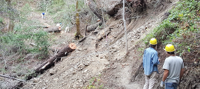
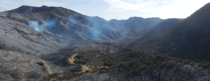
The closure order for portions of the Los Padres remains intact, closing all forest entry into areas that burned during the Thomas Fire.  There has been a lot of confusion and frustration regarding the closure, including the temporary closing of some of the trails outside the burn area.  Suppression repair is wrapping up and BAER (Burned Area Emergency Response) teams remain on the ground working to protect resources in advance of winter storms.  It’ll be a while before the Thomas closure is lifted, please remain patient and obey the closures.

— • — • — • —
Thomas’ Final Gasp?  Lion Canyon, January 2
FOREST 411
• Nearly 6 months after starting on July 8, 2017, the Whittier Fire was officially declared “out” on January 1, 2018.  While flames and smoke stopped months ago, there were a few hot spots that remained in portions of the canyons that were too steep and access too difficult to fully extinguish.  An IR flight team flew the Whittier Fire en route to the Thomas Fire and no heat was sensed from within Whittier.

• Sadly, a 40lb bear was euthanized earlier this week along the Sisar Trail.  The bear was burned during the Thomas Fire and was unable to recover.

• Much of the access to the Los Padres is in jeopardy at the moment due to the oncoming storm.  Slides are expected along forest access roads from Hwy 1 in Big Sur (Soberanes Fire) to 154 in Santa Barbara (Whittier Fire) and down through Hwy 192, 150 and 33 (Thomas Fire).  If you have plans to travel through the forest over the coming week, be sure to check access before you head out.  The CalTrans website is a great resource.

— • — • — • —

Great work by VWA volunteer sawyers along the Spruce Creek Trail in the Silver Peak Wilderness, photo Cypher